Background
Land use changes and energy development, including transmission lines, power lines and pipelines, water diversions and damming, and transportation development, can all impede fish and wildlife movement. The direct result can be mortality or injury to individuals. The indirect result can be fragmentation of fish and wildlife habitat, putting populations at risk and increasing stress on ecosystem services.
Recognizing the movement needs for species, fish and wildlife managers are working with land managers and the public to provide connectivity for fish and wildlife habitat across the landscape, often on working lands or even roadways to provide passage for animals. Providing habitat connectivity is a primary management strategy to maintain species and ecosystem services under a changing climate.
Aquatic Passage
Habitat connectivity is a key component to many facets of terrestrial and aquatic resource management. For Oregon’s native migratory fish, connectivity between aquatic habitats is an important part of garnering successful and healthy populations. Without habitat connectivity, resident or river-dwelling fish species, such as native trout, suckers, and whitefish, become isolated, leading to reduced levels of genetic diversity and fitness. For anadromous (sea-going) populations, fish passage can restore access to habitats that are fertile spawning grounds and pivotal for re-building declining populations. In addition, fish passage also provides access to essential rearing habitats for juvenile species. Obstructions to fish passage can cause migratory fish populations to become genetically isolated and therefore more vulnerable to disturbances that cause mortality to populations or individuals. Currently, many miles of stream habitat in Oregon are not producing fish because of passage barriers.
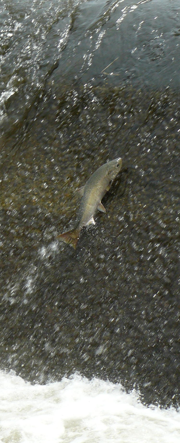
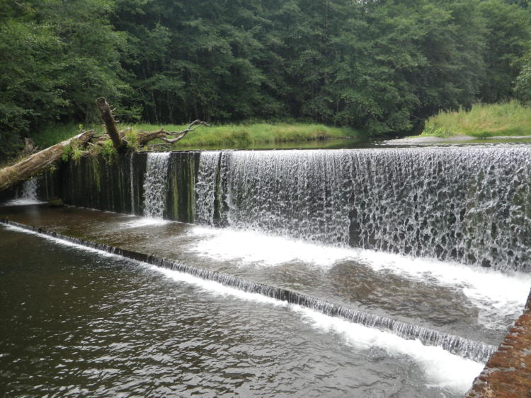
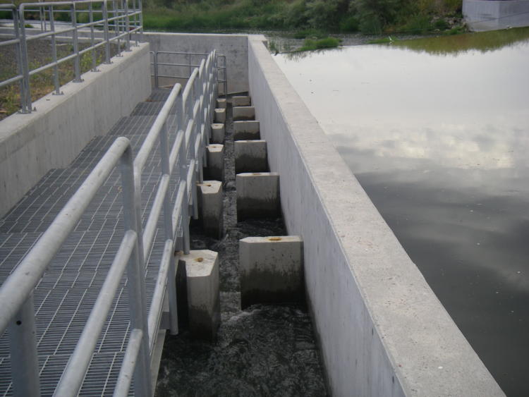
Oregon’s fish passage laws were in place even prior to statehood, but despite these laws, fish passage barriers are prevalent throughout the Oregon landscape. Over time, access to native fish habitats has been blocked or impaired by the construction of impassable culverts, dams, tide gates, dikes, bridges, and other man-made infrastructure. Many of these barriers alter natural flow regimes, create drastic changes in water surface elevations, and interrupt the natural transport of sediment and wood, further contributing to downstream habitat loss. Similarly, improperly-sized culverts can impair passage of amphibians, small and large mammals, and other terrestrial species, forcing wildlife to cross roads where they are vulnerable to vehicles and predators. Providing passage at these artificial obstructions is vital to recovering Oregon’s native migratory fish populations.
Currently, fish passage is required at all artificial obstructions where native migratory fish are or were historically present when a “trigger” event (e.g., abandonment, major replacement, construction, or fundamental change in permit status) occurs. As the state agency responsible for sustaining healthy fish populations, the ODFW works with owners and operators of artificial obstructions in several ways to ensure adequate passage of native migratory fish. Recognizing the unique nature of migratory fish in the Pacific Northwest, many other agencies and groups are also interested in assisting with construction of fish passage.
Fish screens and bypass systems are placed at water diversions (e.g., irrigation systems, hydropower systems) to prevent fish from entering irrigation ditches, turbines, and other habitats detrimental to their survival. Fish screening is an important part of the Oregon Plan for Salmon and Watersheds, a voluntary plan aimed at the protection, restoration, and recovery of native migratory fish, such as salmon and steelhead. Screens and bypass systems must meet the most recent regulatory criteria. Bypasses then move fish back into the stream. This aspect of downstream passage assures that fish stay within natural waterways and are not harmed by these structures. Many unscreened diversions currently result in fish being lost in irrigation systems.
Fish passage restoration is a key to helping native fish adapt to more extreme weather. Habitat connectivity for aquatic species means removing artificial barriers to migration, such as dams and poorly-placed culverts. Restoring fish passage ensures that all life stages of native migratory fish species, as well as aquatic wildlife, are able to move to habitat that meets their needs within a watershed.
Weather extremes may add to the challenges that dams and reservoirs pose to native fish and wildlife. Reservoirs can exacerbate turbidity following big storms by collecting large volumes of muddy water and slowly passing this runoff downstream, long after undammed portions of the watershed have cleared. Muddy water in winter and spring may be much more prevalent in dammed reaches compared to other portions of the individual watersheds.
Aquatic Passage: Goals and Actions
Goal 1: Provide conditions suitable for natural movement of fish and aquatic animals throughout their native range.
Action 1.1. Continue work with the OWEB, ODOT, ODF, USFS, BLM, counties, local municipalities, irrigation districts, and other partners to inventory, prioritize, and provide fish passage at artificial obstructions, enhancing current work done by the ODFW Fish Passage Task Force to expand implementation of fish passage priorities.
Recently developed methods for prioritization of fish passage, incorporating considerations about transportation infrastructure and climate, may help agencies working on these issues in the coming decade. Gathering comprehensive information is an important and ongoing task. Beginning in 2007, the ODFW Natural Resource Information Management Program (NRIMP) began the inventory data management process by creating the Oregon Fish Passage Barrier Data Standard (OFPBDS). This data standard established the type of information (data content), and the format of those data (data structure), needed at every artificial obstruction site to accurately inventory and prioritize fish passage obstructions.
After the creation of the OFPBDS, NRIMP began compiling barrier inventory data from multiple sources throughout the state. Data were obtained from local, state, and federal agencies, watershed councils, tribes, counties, and other entities that possessed fish passage barrier data. These data were compiled, standardized to match the requirements of the OFPBDS, and were loaded into a GIS database. This database represents the most thorough statewide inventory of artificial obstructions to date, and includes information on the number and type of artificial obstructions in the state, as well as the level of fish passage at each barrier, and the physical characteristics of each obstruction. The spatial results of the OFPBDS can be viewed within the ODFW Compass mapping tool.
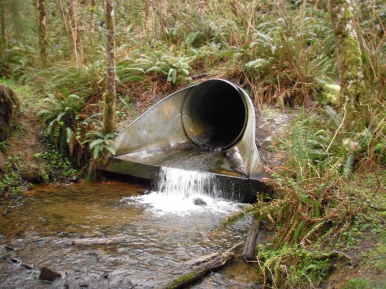
Ground-truthing is still important to verify the current conditions and severity of individual barriers. Fish passage artificial obstructions are structures, such as culverts, dams, tide gates, and levees, that are placed in fish-bearing streams that hinder, or have the potential to hinder, fish passage. The most current information shows that approximately 27,800 fish passage artificial obstructions exist in Oregon. This number continues to grow as our ability to detect structures across the state increases. About 17 percent of these barriers are documented as providing adequate fish passage, 21 percent are complete barriers to fish passage (i.e., block all species), 19 percent are partial barriers, and 43 percent have a “status unknown passage condition”. Of the 27,800 artificial obstructions, culverts make up the vast majority with over 23,000 (83 percent) inventoried, while dams are the next most common barrier type with over 2,500 inventoried (9 percent).
In 2013, ODFW developed a systematic method to prioritize artificial obstructions based on their value to native migratory fish. The list contains 534 high priority fish passage barriers, with an additional 55 barriers characterized as “other significant barriers in need of more data”. Of the 27,800 artificial obstructions documented in Oregon, the 534 priority obstructions comprise less than 2 percent of the total. Among the priority obstructions, 289 (59 percent) are dams, 207 (39 percent) are culverts, and 38 (7 percent) include tide gates, fords, bridges, and other artificial obstructions. Dams make up the majority of the “top” priorities. This is due to the fact that dams generally block large segments of habitat on larger river systems. The priorities have been organized into classes, with each class representing barriers of similar priority ranking.
All barriers on the list are high priorities for the ODFW. The ODFW will continue to work with local, state, and federal partners to remove or provide fish passage at high priority barriers. Per state fish passage law, no new artificial obstructions can be constructed without fish passage, including artificial obstructions used for restoration. ODFW Fish Passage will continue to implement fish passage laws when trigger actions (e.g., new construction, major replacement, abandonment, fundamental change in permit status) occur at artificial obstructions, and will continue to encourage other voluntary actions that provide fish passage.
Action 1.2. Maintain and restore habitat to ensure aquatic connectivity in priority areas such as Conservation Opportunity Areas and areas with high road density such as urban centers.
Road-stream crossing structures include culverts and bridges. These structures have the potential to impact fish passage and aquatic ecosystems. Many culverts have been placed with the primary goal of moving water past the structure efficiently (rather than impounding it, such as occurs with a dam), without consideration of providing fish and wildlife access through the culvert.
Road-stream crossing structures, including habitat improvement projects or mitigation, should be designed and built with the goal of maintaining natural flow and hydrological regimes as well as providing a surface or substrate similar to natural conditions. This goal will ensure the best conditions for both fish and wildlife (including amphibians and aquatic insects) passage. Flow and passage should be maintained through restoration of aquatic habitat connectivity. These efforts should be prioritized based on benefits to aquatic species and location within priority areas, including Conservation Opportunity Areas and densely-populated urban centers. Efforts should also consult ODFW District Fish Biologists and the aquatic barriers database to identify high priority habitat for restoration.
In some situations, coordination among responsible parties and interested partners is required to address the effects of obstructions on the hydrological regime. Coordinating with multiple owners, multiple regulatory levels, and across jurisdictional boundaries, such as with railroads and some hydroelectric projects, can take much more time and negotiation to reach an acceptable outcome, but is critical to long-term success.
Fish passage structures, such as fishways and culverts, must be properly designed or they will be an expensive failure. The ODFW and the National Marine Fisheries Service have existing criteria for fish passage. Agency biologists, consultants, owners and operators of artificial obstructions, and other regulatory entities must be aware of and understand the procedures, criteria, and guidelines in order to assure that the best possible fish passage and stream function are being provided.
Providing fish passage with a fish ladder or properly-sized culvert or bridge is an added expense to the owner or operator of an artificial obstruction. However, there are several financial incentive programs that can be of assistance. The ODFW has a cost share grant program to help with these costs. There also is a small tax credit available for landowners who install qualifying fish screening. Other entities, such as the Oregon Watershed Enhancement Board, also have funds available for high quality fish passage projects. Identifying additional funding sources and incentivizing voluntary landowner passage and screening would be greatly beneficial.
Action 1.3. When planning aquatic passage projects, consider the needs of other aquatic species and terrestrial wildlife in addition to fish.
Most efforts to address aquatic passage have emphasized fish, particularly salmonids, but do not provide adequate passage for all species of fish and wildlife. Pacific lamprey, for example, have a distinct set of passage needs that are not often met with common fish passage facilities. Specialized “lamprey ramps” have been used recently with success to provide adequate passage for lamprey, and these ramps are often needed in addition to salmonid fishways. Similarly, small details within a fishway, such as rounded corners, smooth transitions, and multiple flow paths, can often ensure that fish passage provides benefits to a broad array of species. Although there are currently no requirements to ensure passage for wildlife, ongoing efforts to replace culverts present opportunities for developing, testing, and implementing methods to maximize benefit for a variety of species. Aquatic invertebrates would benefit from making culverts as wide as possible to allow lateral movement of the stream. The embedment of culverts with natural streambed materials provides natural stream-like conditions for both aquatic and terrestrial species passage, including amphibians. In addition, maintenance and restoration of riparian habitat is important to provide wildlife passage adjacent to in-water habitats.
Action 1.4. Continue to screen ditch and pump water diversions to protect fish using funds from Oregon‘s Fish Screening and Passage Cost Sharing Program and working with state and federal funding partners. Implement outreach programs to encourage irrigators to screen intakes, and for construction crews and municipalities to learn best practices for culvert installation.
Barriers are frequently associated with irrigation, municipal, industrial, and hydroelectric water diversions that can cause fish loss in the millions. Continue to provide fish screens at water diversions to keep fish in their natural streams and lakes. Adequately designed screens can keep huge numbers of emigrating salmon and steelhead juveniles, as well as other resident species, from becoming entrained and eventually killed in irrigation diversions or hydroelectric projects. Continued funding, implementation, coordination, and collaboration with multiple stakeholder groups is important for native fish restoration. Provide outreach and technical assistance for irrigators, construction crews, and municipalities.
Terrestrial Animal Movement
Many species rely on the ability to move throughout the landscape to fulfill their needs for survival or complete their life cycles. Some species move seasonally, following food resources, moving to areas more suitable for raising young, or surviving the winter. This may mean moving north and south across thousands of miles, or higher and lower in elevation. Human-caused changes to the landscape can affect the ability of wildlife to move across terrestrial landscapes by adding obstacles, impacting critical stopover sites, and increasing habitat fragmentation. This can have a detrimental impact to many wildlife species.
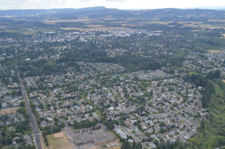
Buildings, landscape development, roads, fences, power line corridors, and other structures can serve as obstacles. Migration is a strong urge in species, and migration routes are often used over decades or centuries by generations of wildlife. So, when a new obstacle pops up in the route, like a roadway or a housing development, wildlife may try to find a way through the area, rather than avoid it. This can lead to increased mortality to wildlife and can endanger human safety. In residential and urban areas, wildlife will move through an open landscape of lawns and backyards. Barking dogs and free-roaming cats, lights from houses, security lighting and street lights, vehicle traffic, and other features people take for granted can be frightening or even lethal to wildlife. Some wildlife species are not welcome in developed areas, and human-wildlife conflicts result. In rural areas, the impacts of roads on wildlife movement will depend on the type of road and the level of use, with impacts increasing with the amount of traffic.
Some wildlife, especially birds, need staging or stopover areas to rest and refuel during migrations. Habitat conversion or degradation can impact important staging or stopover sites, thus impacting the animals that depend on them. Power lines, tower guy wires, and wind turbine blades introduced into migratory flyways of birds and bats impose aerial barriers to flight. Habitat fragmentation can be a barrier to animal movement for vulnerable species. For species that require large continuous habitat, fragmentation reduces the success of the species.
How barriers and habitat fragmentation affect wildlife depends greatly on the species, habitat type, and type of barrier. For example, a two-lane highway may pose a relatively minor barrier to elk, but may be impossible for a turtle to cross. A wind energy facility may not impede deer or pronghorn on the ground, but the spinning turbine blades may pose substantial risk to migrating bats.
These issues can be addressed through careful planning. Human developments and infrastructure can be designed in ways that avoid crucial movement areas for wildlife. Habitat connectivity can be maintained for wildlife through conservation-based design of residential and industrial developments, provision of wildlife crossings along highways, careful siting of renewable energy development, open space conservation, and maintenance or restoration of important migratory stopover sites.
TERRESTRIAL ANIMAL MOVEMENT: Goals and Actions
Goal 2: Provide connectivity of habitat for the broad array of wildlife species throughout Oregon.
When new development is proposed, consider its context within the surrounding landscape. Will it obstruct an important movement corridor for wildlife? How close is it to other developed areas, and what are the cumulative impacts at the landscape scale? Would a higher-density, clustered development leave more open space available for wildlife movement, or would a lower-density development provide greater permeability for wildlife? Leave habitat corridors intact where possible, or provide alternative connecting habitat nearby. Work with community leaders, planners, and agency partners to identify and conserve wildlife movement corridors and to fund and implement site-appropriate mitigation measures.
When evaluating animal movements, consider aerial, underground, seasonal, and nocturnal movement needs. Bat migration patterns are not well understood. Bats may be vulnerable to changing land use patterns, habitat management, and to direct mortality from wind turbines. More information about bat migratory patterns and corridors will help managers respond to growing communities, energy development, forest practices, and other landscape impacts.
Consider the species-specific responses of different types of animals to different types of barriers. For example, the number of lanes and daily traffic volume will have different impacts on animals with different life history traits. Riparian areas are important corridors with many species of wildlife using them to move through the landscape. Other less obvious corridors, such as power line right-of-ways, can play a role, especially in densely-populated urban areas. Corridors may not be appropriate in all cases, so explore other options for providing connectivity. For example, improve connectivity through habitat restoration by enlarging habitat patches and creating links between isolated habitat patches.
Action 2.1. Promote conditions suitable for habitat connectivity throughout Oregon.
Maintain and restore habitat connectivity for wildlife throughout the state by working with conservation lands as well as lands that may be managed primarily for other values, such as forestry, agriculture, residential development, and roadways. Incorporate wildlife information and key life history needs early in land use, energy, and transportation planning processes, and recognize the potential impacts of habitat fragmentation on reducing habitat quality and increasing stress on populations.
Consider distribution of at-risk Strategy Habitats and work to maintain or restore large blocks of native habitat types. Maintain riparian areas whenever possible, and plant them with native plants to provide food and cover. Remove or discourage invasive species to the extent possible.
Consider ways to provide for connections and migratory pathways among Conservation Opportunity Areas and other priority areas for conservation. Incorporate new information about the impacts of climate change.
Action 2.2. Continue to collect terrestrial wildlife movement data, and refine maps and models to better identify and prioritize wildlife movement corridors.
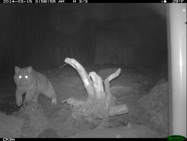
Two types of information are crucial to understand wildlife habitat connectivity: (1) documented wildlife observations, and (2) modeled information about vegetation, topography, and other aspects of the landscape. It is important to continue to collect and improve both types of information, using actual observations of fish, wildlife, and habitats to inform the models. The information should be made available to planning organizations and the public to facilitate conservation of habitat connectivity.
While some broad-scale, west-wide wildlife habitat maps are available from the Western Association of Fish and Wildlife Agencies Crucial Habitat Assessment Tool, there is a need to develop finer-scaled maps and more specific tools and interpretation guidelines. Finer-scaled maps could be used in the natural resource inventories of land use plans, to inform siting and design of renewable energy development, and to help refine connectivity among and within Conservation Opportunity Areas.
- Priority Wildlife Connectivity Areas (PWCAs): Priority Wildlife Connectivity Areas are an informational tool to guide the work of all entities engaged in land, wildlife, and other natural resource conservation and management, including state, federal, county, and local governmental organizations, sportsmen’s organizations, conservation groups, NGOs, and private landowners interested in restoring, enhancing, and protecting habitat important for wildlife connectivity. These PWCAs were identified as part of the Oregon Connectivity Assessment and Mapping Project, and represent the parts of the landscape with the highest overall value for facilitating wildlife movement. Focused investments in habitat within PWCAs can increase the likelihood of long-term maintenance of wildlife connectivity in Oregon, maximize effectiveness over larger landscapes, improve funding efficiency, and promote cooperative efforts across ownership boundaries, resulting in interconnected movement pathways for wildlife in the state.
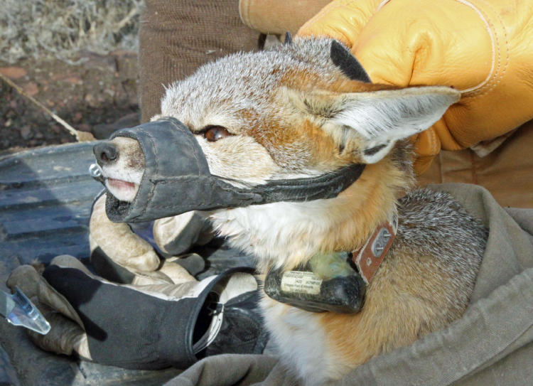
- Secretarial Order 3362: In February of 2018, then-Secretary of the Interior Zinke signed Secretarial Order 3362, “Improving Habitat Quality in Western Big-Game Winter Range and Migratory Corridors.” The Order directs the bureaus within the Department of the Interior to work closely with western states to enhance and improve the quality of big-game winter range and migration corridor habitat on Federal lands. Oregon’s State Action Plan for implementation of Secretarial Order 3362 outlines needs for data collection and analyses that will help execute the Order, as well as several winter range areas and migratory corridors in the state that would benefit from immediate habitat improvements and/or transportation mitigation. In September of 2019, with funding assistance from the BLM, ODFW captured and deployed GPS tracking collars on 161 pronghorn in southeastern Oregon. These collars, which will record one GPS location every four hours for each animal, will provide fine-scale data to help the agency delineate pronghorn migratory pathways and seasonal range use, and identify barriers to pronghorn movement. These data will also be used in validating the connectivity models developed in the Oregon Connectivity Assessment and Mapping Project.
- House Bill 2834: In June of 2019, the Oregon Legislative Assembly passed House Bill 2834, an act relating to wildlife corridors. The bill mandates that ODFW collect, analyze, and develop the best available science and data regarding connectivity of wildlife habitat areas, and to use the data to develop a plan, to be known as the Wildlife Corridor Action Plan. The Wildlife Corridor Action Plan will be used to preserve long-term habitat connectivity for wildlife and provide guidance for all state agencies to develop benchmarks for the designation and protection of wildlife corridors in Oregon. The bill also directs ODOT to establish a program to reduce wildlife-vehicle collisions in areas where wildlife corridors identified in the Wildlife Corridor Action Plan intersect with proposed or existing public roads.
Action 2.3. Enhance wildlife habitat and connectivity with consideration of climate change impacts.
Fluctuations in climate can impact the quality and quantity of wildlife habitat for some species, resulting in potential shifts in species ranges. The range for one species may decline or become fragmented, while expanding for another. Many species are not able to adapt quickly enough to shift their range as the climate changes.
Monitoring wildlife habitats and seeking opportunities to maintain or enhance natural landscapes, habitat connectivity, and providing refugia are primary management strategies to help balance species viability and distribution in response to a fluctuating climate. However, management actions intended to account for climate change will need to be continuously evaluated as new information becomes available so that we are developing refugia for future populations and species as the climate changes the environment. Provide species a range of options to adapt to climate change by restoring and expanding areas along a gradient of climates. As part of a region-wide effort, The Nature Conservancy produced a map of landscape resiliency in Oregon, available for consultation and inclusion with project and planning efforts.
Action 2.4. Identify, maintain, and restore important stopover sites for migratory birds and bats.
To fully address wildlife habitat connectivity needs in Oregon, connectivity planning efforts within the state should address the connectivity needs of aerial species, such as birds and bats.
Migrating birds may use stopover sites only briefly during a given year, but these stopover sites are as essential to wildlife survival as the territories they occupy for longer periods. When birds migrate, they expend a great deal of energy each day. They must stop to rest and feed one or more times each day and at night to refuel for the journey. Many sites, such as wetlands and mudflats, are in lowland areas which are important areas for development. Some areas, such as agricultural fields, can be important for migrating birds, especially shorebirds.
Use existing information on the location and value of known stopover sites when planning for new development. Work with partners to maintain and restore priority sites, such as Audubon’s Important Bird Areas or important shorebird areas. In particular, look for ways to avoid or minimize impacts to important sites. If impacts are unavoidable, mitigate for any impacts by providing alternative sites nearby and minimize disturbance during critical migration periods, such as the spring and fall. Look for opportunities to work with landowners to provide and enhance bird habitat.
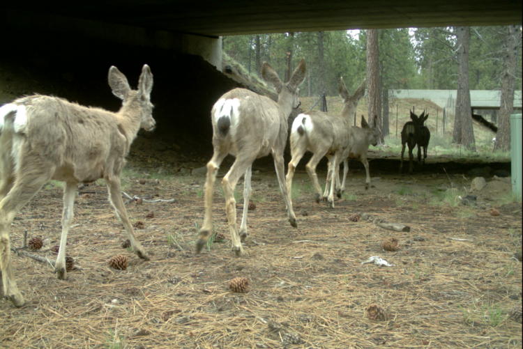
Action 2.5. Work with ODOT, county transportation departments, and other partners to identify and address key areas of wildlife mortality on highways and consider animal movements when planning new roads.
Wildlife cannot avoid roads, railroads, and other linear obstructions. The result is sometimes injury or death for wildlife. In the case of vehicle-wildlife collisions, people are at risk as well. Ideally, wildlife movement should be considered during the planning phase of new roads to avoid known migratory routes and to design wildlife passage into the project.
Existing roads affect both waterways and wildlife. Some established wildlife migratory routes that intersect roads can be identified by local or state road crews who repeatedly remove road-kill carcasses at these spots. In these cases, bridge replacement and routine highway maintenance provide opportunities to address areas where highway mortality is high. For smaller wildlife species, a culvert under the road may help small mammals, reptiles, and amphibians cross safely. Install warning signs for drivers about wildlife crossings. Funnel larger species to larger culverts or underpasses. Additional studies may be needed to advance understanding of wildlife-transportation corridor conflicts, as well as design approaches, so that preventative, cost-effective solutions can be incorporated into project designs.
Action 2.6. Promote strategies to increase permeability of urban landscapes for wildlife.
Examples include connecting urban natural areas and riparian corridors, supporting and promoting the use of green infrastructure in urban planning, and reducing direct hazards to wildlife. For more information, see the section on Conservation in Urban Areas.